Islamabad and Rawalpindi, Pakistan
November 3, 2003
Credits:NASA for image and text
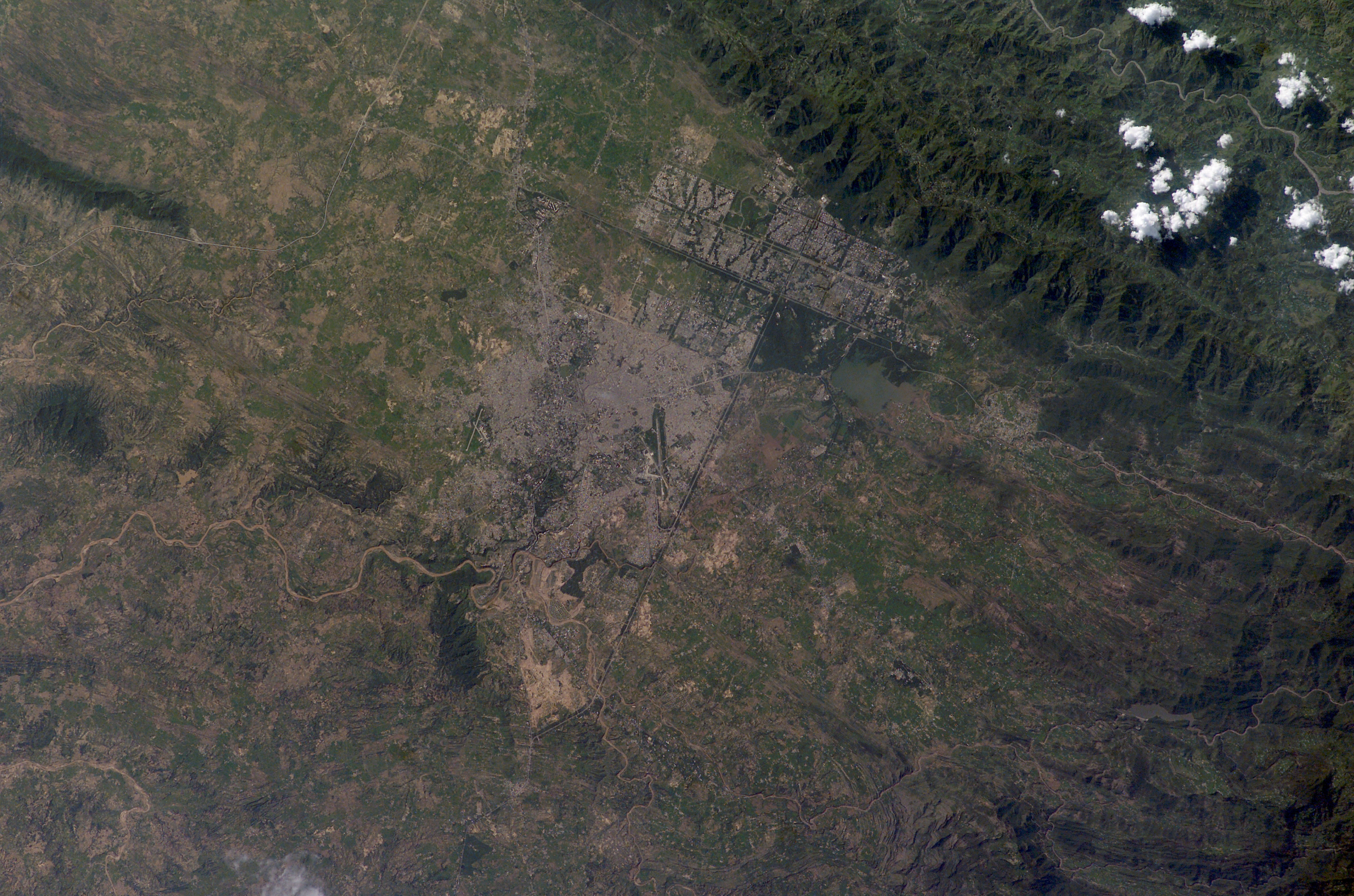
Two capital cities in Pakistan lie next to one another but display land use patterns that are entirely different. Islamabad, with a population of 901,000 (ca. 1998) boasts a master-planned rectangular street pattern nestled against the Margala Hills (top left). The larger Rawalpindi (population 1,406,214 in 1998) lies to the south on the Soan River.
Islamabad has grown rapidly since construction began in 1961. It was created as a new administrative district in Pakistan to be the home of government, the supreme court, and the diplomatic corps. The great white building of the Faisal Mosque appears on the northern margin of the city. By contrast with orthogonal Islamabad, Rawalpindi displays the radial land transportation pattern of many cities with a river flowing through the city center. City blocks are small and growth less controlled than in its newer neighbor. Airports can be seen to the east and south.
Rawalpindi was an important British military center from the mid-1800s during colonial times, and became the interim capital for a decade (1959–69) once the decision was made to move the capital from Karachi inland to be closer to disputed Kashmir and neighboring Muslim countries. Rawalpindi is the headquarters of Pakistan’s army and an administrative, commercial, educational and industrial centre.
download large image (4 MB, JPEG, 6144x4068)
Astronaut photograph ISS007-E-13090 was taken August 21, 2003 with a Kodak DCS760 digital camera equipped with a 180 mm lens. Image interpretation is provided by M. Justin Wilkinson (Lockheed Martin/Earth Observations Laboratory, Johnson Space Center). The International Space Station Program supports the laboratory to help astronauts take pictures of Earth that will be of the greatest value to scientists and the public, and to make those images freely available on the Internet. Additional images taken by astronauts and cosmonauts can be viewed at the NASA/JSC Gateway to Astronaut Photography of Earth. Instrument(s):
ISS - Digital Camera
Karachi, Pakistan
Credits:NASA for image and text
Two capital cities in Pakistan lie next to one another but display land use patterns that are entirely different. Islamabad, with a population of 901,000 (ca. 1998) boasts a master-planned rectangular street pattern nestled against the Margala Hills (top left). The larger Rawalpindi (population 1,406,214 in 1998) lies to the south on the Soan River.
Islamabad has grown rapidly since construction began in 1961. It was created as a new administrative district in Pakistan to be the home of government, the supreme court, and the diplomatic corps. The great white building of the Faisal Mosque appears on the northern margin of the city. By contrast with orthogonal Islamabad, Rawalpindi displays the radial land transportation pattern of many cities with a river flowing through the city center. City blocks are small and growth less controlled than in its newer neighbor. Airports can be seen to the east and south.
Rawalpindi was an important British military center from the mid-1800s during colonial times, and became the interim capital for a decade (1959–69) once the decision was made to move the capital from Karachi inland to be closer to disputed Kashmir and neighboring Muslim countries. Rawalpindi is the headquarters of Pakistan’s army and an administrative, commercial, educational and industrial centre.
download large image (4 MB, JPEG, 6144x4068)
Astronaut photograph ISS007-E-13090 was taken August 21, 2003 with a Kodak DCS760 digital camera equipped with a 180 mm lens. Image interpretation is provided by M. Justin Wilkinson (Lockheed Martin/Earth Observations Laboratory, Johnson Space Center). The International Space Station Program supports the laboratory to help astronauts take pictures of Earth that will be of the greatest value to scientists and the public, and to make those images freely available on the Internet. Additional images taken by astronauts and cosmonauts can be viewed at the NASA/JSC Gateway to Astronaut Photography of Earth. Instrument(s):
ISS - Digital Camera
Karachi, Pakistan
February 5, 2010
Credits:NASA for image and text

A centuries-old settlement that now ranks among the world’s largest, Pakistan’s seaport city of Karachi mixes intense urbanization with remnants of a natural environment. The Advanced Land Imager (ALI) on NASA’s Earth Observing-1 (EO-1) satellite captured this true-color image of Karachi on January 8, 2010. It shows the southwestern edges of the city, where mangroves and river deltas mix with ports and pavement.
Two rivers, the Lyari and Malir, pass through Karachi en route to the Arabian Sea. The Lyari River passes north of the Port of Karachi, and expansive salt works, appearing as large geometric areas of green, line the northern edge of that river’s delta. East of the port, the Malir River flows southward toward the sea. Emptying through a narrower delta, the Malir River is nevertheless more conspicuous than its neighboring waterway; the river is wider, and the corridor of vegetation along its banks extends farther out into the city.
Karachi’s port does not open directly to the Arabian Sea. Between the port and the ocean, a barrier island runs northwest-southeast (shown along the left edge of the image). East of this island and west of the port sits a large expanse of water and mangroves. Water in the Lyari River Delta must empty into the sea through the Baba Channel. (Tiny, oblong slivers in the channel are probably large ships.) Sediment colors the water flowing through that channel a lighter color than the surrounding ocean. Immediately east of the Port of Karachi lie two more mangroves, the larger of which is named Chinna Creek.
Away from the coastal mangroves, cityscape predominates. Many of Karachi’s oldest structures and most popular tourist attractions appear in the city center just northeast of the port, but street grids cover almost all of the available land outside of the mangroves. According to census statistics from 2000 to 2005, Karachi had a population of over 12 million inhabitants in 2006, and it was expected to maintain a high growth rate over the next decade.
References
City Mayors Statistics. The world’s largest cities and urban areas in 2006. Accessed January 27, 2010.
Wikipedia. Karachi. Accessed January 25, 2010.
NASA Earth Observatory image by Jesse Allen, using EO-1 ALI data provided by the NASA EO-1 team. Caption by Michon Scott. Instrument(s):
EO-1 - ALI
No comments:
Post a Comment